Dernière modification / Last update: 6 juin 2018
| Code |
EGEN | ||||||||||||||||||||||||||||||||||||
|---|---|---|---|---|---|---|---|---|---|---|---|---|---|---|---|---|---|---|---|---|---|---|---|---|---|---|---|---|---|---|---|---|---|---|---|---|---|
| Coordonnées Coordinate |
|
||||||||||||||||||||||||||||||||||||
| Pays Country |
 Royaume-Uni (GB) Royaume-Uni (GB) |
||||||||||||||||||||||||||||||||||||
| Type de trafic Type of traffic |
VFR | ||||||||||||||||||||||||||||||||||||
| VFR nuit Night VFR |
Non / No | ||||||||||||||||||||||||||||||||||||
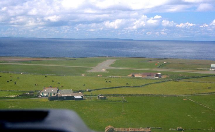
| Pistes Runways |
|
||||||||||||||||||||||||||||||||||||
| Radio ATC |
|
||||||||||||||||||||||||||||||||||||
| Altitude de référence Reference elevation |
56 ft | ||||||||||||||||||||||||||||||||||||
| Distance de la ville Distance of the city |
50 km NE Kirkwall | ||||||||||||||||||||||||||||||||||||
| Déclinaison Magnetic varation |
2.12°W | ||||||||||||||||||||||||||||||||||||
| Gestionnaire de l'AD AD administration |
ORKNEY ISLANDS COUNCIL +44 1856-873535 developmentandinfrastructure@orkney.gov.uk |
||||||||||||||||||||||||||||||||||||
| Douanes Customs |
NIL |
||||||||||||||||||||||||||||||||||||
| ATS |
NIL |
||||||||||||||||||||||||||||||||||||
| HOR AD |
Associé à un PPR / Subject to PPR |
||||||||||||||||||||||||||||||||||||
| PPR |
OUI / Yes |
||||||||||||||||||||||||||||||||||||
| AVT |
NIL |
||||||||||||||||||||||||||||||||||||
| Aéroclub / Ecole de pilotage Flying club / Flying school |
NIL |
||||||||||||||||||||||||||||||||||||
| Vidéos Videos |
|||||||||||||||||||||||||||||||||||||
| Liens Links |
|||||||||||||||||||||||||||||||||||||
| Carte - Hôtel Map - Hotel |
Booking.com | ||||||||||||||||||||||||||||||||||||