Dernière modification / Last update: 29 juin 2018
| Code |
EGPC | |||||||||||||||||||||||||
|---|---|---|---|---|---|---|---|---|---|---|---|---|---|---|---|---|---|---|---|---|---|---|---|---|---|---|
| Coordonnées Coordinate |
|
|||||||||||||||||||||||||
| Pays Country |
 Royaume-Uni (GB) Royaume-Uni (GB) |
|||||||||||||||||||||||||
| Type de trafic Type of traffic |
VFR, IFR | |||||||||||||||||||||||||
| VFR nuit Night VFR |
Oui / Yes | |||||||||||||||||||||||||
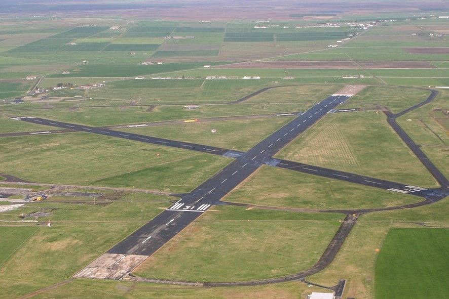
| Pistes Runways |
|
|||||||||||||||||||||||||
| Radio ATC |
|
|||||||||||||||||||||||||
| Altitude de référence Reference elevation |
126 ft | |||||||||||||||||||||||||
| Distance de la ville Distance of the city |
1.8 km N Wick | |||||||||||||||||||||||||
| Déclinaison Magnetic varation |
2.25 °W | |||||||||||||||||||||||||
| Gestionnaire de l'AD AD administration |
HIAL +44 1955-607583
|
|||||||||||||||||||||||||
| Douanes Customs |
O/R h HIAL ou Far North Aviation +44 (0) 1955 602201 |
|||||||||||||||||||||||||
| ATS |
HOR AD |
|||||||||||||||||||||||||
| HOR AD |
Lun → Jeu / Mon → Thu 0700 – 2030 (0600 – 1930) Ven / Fri 0815 – 2030 (0715 - 1930) Dim / Sun 1515 – 1715 (1415 - 1615)
|
|||||||||||||||||||||||||
| PPR |
Oui / Yes |
|||||||||||||||||||||||||
| AVT |
H24 Far North Aviation +44 (0) 1955 602201 andrew@farnorthaviation.co.uk AVTUR JET A-1 |
|||||||||||||||||||||||||
| NDB / VOR-DME |
NDB WCK 344.00 kHZ / VOR WIK 83X |
|||||||||||||||||||||||||
| Aéroclub / Ecole de pilotage Flying club / Flying school |
Far North Aviation Ltd +44 (0) 1955 602201 andrew@farnorthaviation.co.uk |
|||||||||||||||||||||||||
| Restaurant Restaurant |
En ville / In the city
|
|||||||||||||||||||||||||
| Taxis Taxis |
Jimmys Taxis +44 1955 602727 Johnnies Taxis +44 1955 605041 |
|||||||||||||||||||||||||
| Vidéos Videos |
||||||||||||||||||||||||||
| Liens Links |
||||||||||||||||||||||||||
| Carte - Hôtel Map - Hotel |
Booking.com | |||||||||||||||||||||||||