Dernière modification / Last update: 3 novembre 2018
| Code |
ENHA | |||||||||||||||||||||||||
|---|---|---|---|---|---|---|---|---|---|---|---|---|---|---|---|---|---|---|---|---|---|---|---|---|---|---|
| Coordonnées Coordinate |
|
|||||||||||||||||||||||||
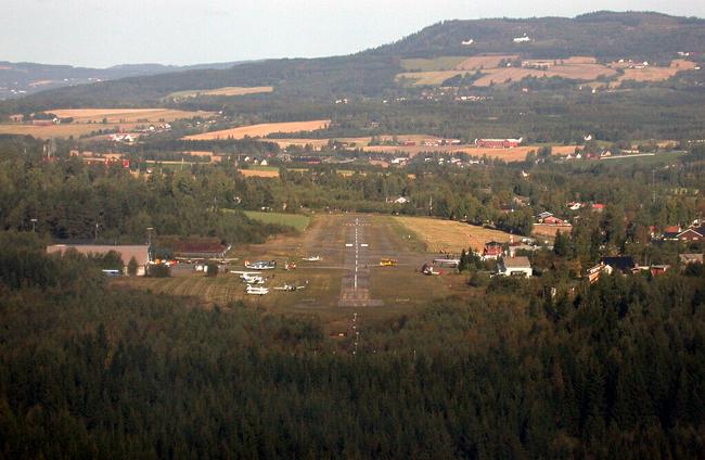
| Pays Country |
Norvège | |||||||||||||||||||||||||
| Type de trafic Type of traffic |
VFR | |||||||||||||||||||||||||
| VFR nuit Night VFR |
Non / No | |||||||||||||||||||||||||
| Pistes Runways |
|
|||||||||||||||||||||||||
| Radio ATC |
|
|||||||||||||||||||||||||
| Altitude de référence Reference elevation |
729 ft | |||||||||||||||||||||||||
| Distance de la ville Distance of the city |
0 km Hamar | |||||||||||||||||||||||||
| Gestionnaire de l'AD AD administration |
Hamar Lufthavn (+47) 62 52 20 80 |
|||||||||||||||||||||||||
| Douanes Customs |
NIL |
|||||||||||||||||||||||||
| HOR AD |
H24 Sauf férié et Dim / Except HOL and Sun 1030 – 1200 |
|||||||||||||||||||||||||
| AVT |
JET A1 - 100LL Statoil card |
|||||||||||||||||||||||||
| Aéroclub / Ecole de pilotage Flying club / Flying school |
Hedmark Flyklubb +47 950 80 130 |
|||||||||||||||||||||||||
| Restaurant Restaurant |
En ville / In the city |
|||||||||||||||||||||||||
| Taxis Taxis |
Jon-Terje Knutsen +47 413 00 923 Kenneth Vesterås +47 959 50 035 |
|||||||||||||||||||||||||
| Vidéos Videos |
||||||||||||||||||||||||||
| Liens Links |
||||||||||||||||||||||||||
| Carte - Hôtel Map - Hotel |
Booking.com | |||||||||||||||||||||||||