Dernière modification / Last update: 5 novembre 2018
| Code |
ENSS | |||||||||||||||||||||||||
|---|---|---|---|---|---|---|---|---|---|---|---|---|---|---|---|---|---|---|---|---|---|---|---|---|---|---|
| Coordonnées Coordinate |
|
|||||||||||||||||||||||||
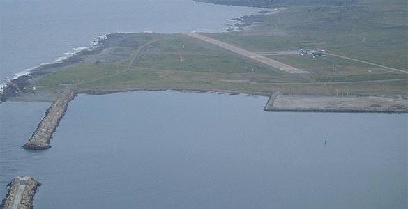
| Pays Country |
Norvège | |||||||||||||||||||||||||
| Type de trafic Type of traffic |
VFR, IFR | |||||||||||||||||||||||||
| VFR nuit Night VFR |
Oui / Yes | |||||||||||||||||||||||||
| Pistes Runways |
|
|||||||||||||||||||||||||
| Radio ATC |
|
|||||||||||||||||||||||||
| Altitude de référence Reference elevation |
42 ft | |||||||||||||||||||||||||
| Distance de la ville Distance of the city |
2,5 km SW Vardø | |||||||||||||||||||||||||
| Déclinaison Magnetic varation |
15° E | |||||||||||||||||||||||||
| Gestionnaire de l'AD AD administration |
Avinor (+47) 67 03 52 55 |
|||||||||||||||||||||||||
| Douanes Customs |
NIL |
|||||||||||||||||||||||||
| ATS |
Lun → Ven / Mon → Fri 0730 – 2100 Sam / Sat Fermé / Closed Dim / Sun 1630 – 2130 |
|||||||||||||||||||||||||
| HOR AD |
Lun → Ven / Mon → Fri 0730 – 1430 |
|||||||||||||||||||||||||
| AVT |
JET A1 |
|||||||||||||||||||||||||
| NDB / VOR-DME |
VOR VRD 114,10 MHz |
|||||||||||||||||||||||||
| Aéroclub / Ecole de pilotage Flying club / Flying school |
NIL |
|||||||||||||||||||||||||
| Restaurant Restaurant |
En ville / In the city |
|||||||||||||||||||||||||
| Taxis Taxis |
Taxi +47 78 98 73 71 Harald Marthinussen Taxi +47 78 98 83 33 |
|||||||||||||||||||||||||
| Vidéos Videos |
||||||||||||||||||||||||||
| Liens Links |
||||||||||||||||||||||||||
| Carte - Hôtel Map - Hotel |
Booking.com | |||||||||||||||||||||||||